Wednesday, 10 July 2013

BRISBANE BOTANICAL GARDENS, QLD. AUS. via the Go Between bridge

Brisbane Botanic Gardens

Last Saturday I rode with U3A Peddling for Pleasure from Norman Park station to Park Road station via The Brisbane Botanic Gardens and the University of Queensland.


This river and city scape was taken from Mowbray Park in East Brisbane on a perfect winter's morning

As can be seen in the above photograph, we had the perfect weather for cycling and whilst some of the group availed themselves of the public conveniences in the park, I managed to take a couple of photographs of the Brisbane River with the city in the background. This is what living in Brisbane is all about, a modern laid back city with a beautiful river winding it's way through it, affording many spots along the river to either cycle,walk, picnic or laze in the sun in the many parks along it's banks and if that's too much like hard work, there are many restaurants to meet up with old friends to share lunch or a cup of coffee.
 
 
Dockside


Creative use of an old dry dock


As we continued out ride along the river we passed through Dockside which is a multi-dwelling estate built on and around the site of the old dry dock . Most of the units in this estate have extensive views of the city and it's surround and makes for a great place to live if working in the city due to it's close proximity to the CBD.


The cycleway hugging the river past Dockside heading towards the Storey bridge spanning the river at Kangaroo Point.


We followed the river through Kangaroo Point and under the Storey Bridge, past the cliffs and under the Captain Cook Bridge, past the Maritime Museum, past the South Bank Parkland and under the Victoria bridge, passing the Cultural Centre, Queensland Art Gallery, Museum and Gallery of Modern Art, under the Kurilpa Pedestrian Bridge and the William Jolley Bridge, continuing on until we reached the Go Between Bridge which we crossed to continue the ride along the Bicentennial Bike way until we reached the tunnel taking us under Coronation drive and onto Sylvan Road in Toowong, turning left onto Milton Road which lead into Mt. Cootha Road and onto the Brisbane Botanic Gardens.


Peddling For Pleasure arriving at our favourite spot in the Brisbane Botanic Gardens


The Brisbane Botanic Gardens is a sub-tropical botanic garden built on 52 hectares located at the foot of Mt. Cootha, Brisbane's tallest mountain. There is a restaurant/cafe on the grounds near the crop of bamboo depicted in the above photograph which serves takeaway coffee.


Cycling the approach to the Eleanor Schonell Bridge

We were reluctant to leave such a beautiful location but instead of returning to Norman Park we retreated as far as the Bicentennial Cycleway, turned right and headed for the University of Queensland at St. Lucia


A view of The University of Queensland

Leafy St. Lucia

Eleanor Schonell Bridge

It is only a short ride from the Gardens to the university and is quite easy to navigate. Once the Eleanor Schonell Bridge is located and crossed it is simply a matter of following the bike path to Park Road Station. The entire ride is only about 24.5 km and if the sun is shining brightly, it will be one of the most enjoyable rides you could imagine.


Although the focal point of this ride is the Botanical Gardens, it runs through the following suburbs and can be started from either end or for that matter in any of the following suburbs : Norman Park, East Brisbane, Kangaroo Point, South Brisbane, South Bank, Milton, Toowong, Taringa, St. Lucia, Dutton park (Park Road Station).

Cheers and safe riding,


Jimmy Bee

Monday, 1 July 2013

CLIFTON LOOP, QLD. AUS. via Kratzman & Old Elphinstone Road


This view was taken from the junction of Kratzman Road with the New England Highway

Cycling is made so much easier when you have smooth surfaces and captivating scenery. This particular loop could be ridden with any type of bicycle and is just one of many routes that can be taken in the Clifton district. I'm particularly lucky because normally, I get to ride in this area every four to six weeks and therefore can experience all four seasons.


This view of the flowering trees was also taken from Kratzman Road

When travelling by bicycle, there is a greater awareness of our surroundings and it is so easy to just stop and frame the scene in a moment of time.


A north west view taken from Kratzman Road


It is great to get out in the countryside away from the city buzz, however, if you are travelling by car, I find it so much harder to make the effort to stop awhile and admire the view, whereas when cycling I am compelled to, as I feel more akin to the surroundings and it's constantly changing panoramas.


This patch of sunflowers was also taken on this ride.


These photographs were taken coming into winter and as I intend to ride this route in spring you can back it in that it will be a whole different kaleidoscope of colours and a whole new suite of images.

A beautiful crop of sorghum on Old Elphinstone Road


The above map was created by using mapmyride. Of all the map sites I have tried, this one in my view is the most superior....Why?.....because it is easy to use, accurate and if required measures not only the elevation but also the gradient of the climb which can be invaluable when planning a ride.


Cheers and safe riding,


Jimmy Bee

Thursday, 27 June 2013

*CYCLING PARK TO PARK, BRISBANE, QLD. AUS. -- Newstead Park to Norman Park

 
The bike way runs along the waterfront with Brisbane skyline in the background.


This ride takes you on  bike ways which run along the side of the Brisbane River for most of the journey and as such makes it one of the most picturesque rides in Australia.


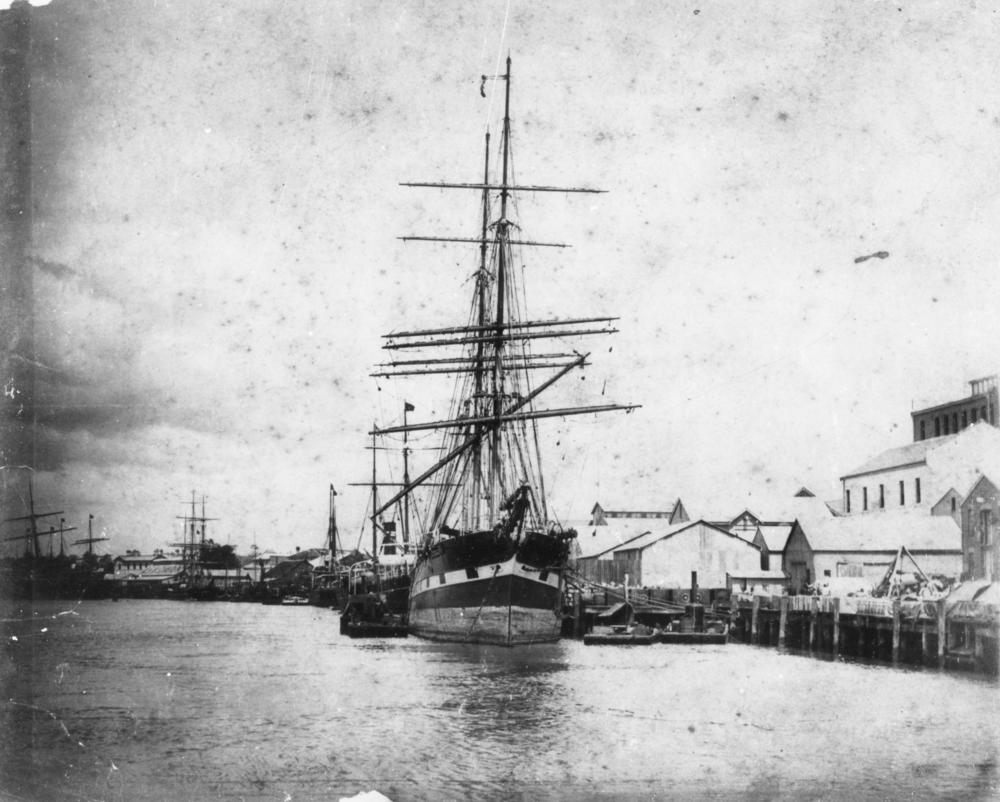
File:StateLibQld 1 115048 Unidentified sailing ships moored at Eagle Street Wharves, Brisbane, ca. 1885.jpg

This is a good representation as to how the  upper scene would have looked in the mid to late 1800's


This waterfront is steeped in history. Up until quite recently, this was all wharf area originally  servicing sailing ships bringing whatever was needed in starting up a new colony including  wide eyed migrants from the other side of the world with expectations of making a new life for themselves and their families. My own family ancestors would have been on one or other of those ships in the mid 1800's as they originated from Ireland, Scotland and England. If only they could see it now.


File:StateLibQld 1 186675 United States Army base at Bulimba during World War II.jpg
American forces base in Bulimba, Qld. with troopship in the background


During World War 2, Brisbane was the staging post for the battle of the Pacific with General Douglas MacArthur's headquarters located here. As well as our own troops, there were thousands of Americans and hundreds of warships moving in and out of Brisbane during these turbulent years.


The entrance to Breakfast Creek from the Brisbane River

 
 As this ride is from Newstead park to Norman Park, we start from the entrance to Breakfast Creek which runs adjacent to the northern side of the park. Just for your information, there are some fantastic rides on the other side of this creek as well, a number of which I have already posted about.


Above are an assortment of views on this bike way as it makes it's way from Newstead Park through Teneriffe, New Farm, Brisbane City, past the City Botanic Gardens, across the Goodwill Bridge to South Brisbane.

After crossing the Brisbane River the ride meanders through Kangaroo Point, East Brisbane to Norman Park. Following are a number of views of this stretch of the south side of the river.


This ride is suitable for the family, being 36km long and if this proves to be too long there is the option of catching a ferry back from several ferry terminals along the way.

Brisbane may not be the tourist mecca of the world but it is a great place to live. Perhaps I am wrong with this statement, as a British Rugby Union fan visiting our beautiful city a short time ago said,  "In Brisbane you don't have to make plans you just hit the town and wing it for a fantastic time."

Cheers and safe riding,


Jimmy Bee

Tuesday, 18 June 2013

CYCLING CLIFTON, QLD. AUS. -- Cambooya return via Nobby


I know I have stated this before, but this part of the Darling Downs in Queensland is truly a great place to ride. Why?......well, for a start it is only 2 hours drive from Brisbane and 40 minutes from Toowoomba if you strike serious mechanical problems with your bike. All of the rides could be classed as easy to moderate depending on your level of fitness. The road surfaces are mainly sealed but there are a few dirt roads which can cause you a little grief after rain. There are enough hills to get the pulse rate up but although long, the gradient would only vary between 2 and 4 percent. You can experience four seasons within the year but not to the extreme. At the height of summer you can experience some hot days and in winter early frosts and of course the dreaded westerlies in August. I am only an intermediate recreational cyclist and have experienced all of the above conditions from time to time but nothing that has caused me any real angst. When you ride through the varying panoramic vistas throughout the district the rest pales into insignificance. The routes will take you from east to west and north to south and it is just as easy to spend a week here as it is a day and the traffic is generally light.


Clifton to Cambooya.......55 km return
 
I wasn't aware of the potential of this ride until a friend pointed it out as being an alternate route to Toowoomba but with the fraction of the traffic one would encounter on the New England Highway. My wife and I decided to check it out  and I found to my delight that it would make an excellent ride that would be of interest to both the riders of road bikes and hybrids alike.
 
My brother in law and I decided to ride it on a beautiful morning over the Easter weekend. The ride to Cambooya was pleasant and we encountered very light traffic, possibly because it was a holiday. We took our time whilst admiring the many and differing rural views particularly as we were climbing the only hill on the route.


Cambooya is another small rural town servicing the many small crop farmers within it's district. We took the opportunity to take on fuel at a local cafe and admired the well known Bull and Barley Hotel which has the reputation of serving delicious meals (click on the blue print for a direct link).


 There are a couple of other roads between Cambooya and Clifton but, as we were both heading back home after the Easter break, we decided, due to time constraints, to backtrack along the same route.
 
 
Map courtesy of "Map my Ride"
 
 I find that Map my Ride maps are easy to use and due to incorporating the elevation are invaluable when planning an exploratory ride.
 
Cheers and safe riding,
 
 
Jimmy Bee


Tuesday, 4 June 2013

CYCLING THE GAP TO ALBION, QLD. AUS. via Enoggera Creek


As I stated in my last post "The Gap",  you can either retrace your ride from The Gap to where you started the ride or alternatively, follow Enoggera Creek to Albion Railway Station.


Add caption


The above map only depicts where the overall route can take you including possible start and finish points. Each kilometer of the ride is flagged with a number. The alternative route along Enoggera Creek starts at flag 12, St. Johns Wood and finishes with the red flag (partially obscured at the top of the map) which is Albion Railway Station.


When looking at the above collage, you can imagine being in a nice serene setting to while away some time or maybe to contemplate and solve a problem you may have.


When the flooding rains come, this creek becomes a whirling mass  of water capable of taking out bridges and inundating houses causing millions of dollars of damage. Mother Nature has a way of letting us know who is boss.


When riding, I'm always on the lookout for beautiful or unusual architecture to photograph. The above photographs show some of the house designs found around the inner suburbs of Brisbane and originally built in the earlier part of the 20th century and of course, beautifully kept or renovated. Having owned and lived in this type of house over the years, I found them to be suitable to the Queensland climate with their large, open planning and high ceilings, allowing for the flow of air and having sufficient windows, suitably situated to catch the prevailing breezes. I often wondered about the stories and family secrets these homes held of the previous occupiers. It's almost as if wood has a soul, as you can feel it move  and hear it creak at night and you sense that it really does have something to tell you.


Is this building a blight on the urban landscape or could it, with a bit of  architectural flair and ability, be turned into a beautiful urban landmark, perhaps a number of theatres with associated bars and restaurants. What do you think, if you had the money, would you put it at the mercy of the wreckers ball or would you prefer to see it turn into something admired by many. So many buildings these days, tall and small alike,  are put up just to turn a dollar, they have no identity, just beige and lifeless.


Here is an imaginative bit of window dressing which made an ugly road system more easy on the eye. When taking this photograph, my eye was drawn to the blending of colours, line, form and texture and I found it somehow compelling to capture it.

This is the type of ride to take on a weekend after a week in the workplace you would rather forget. It can be ridden alone, with a friend or the whole family, it is an urban escape and you have earned it, now enjoy it.

Cheers and safe riding,

Jimmy Bee